How to use the Metro
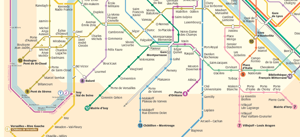
OK, because you're all so undone about it, so I'll show you how to use the metro. Below I've reproduced a portion of the map on the "Transportation within Paris" page (this is the southwest corner of the city).
Let's suppose you're at Charles Michels (on the gold line, number 10), and you want to go to Campo Formio (on the orange line, number 5). Take a moment to locate these two stops. I'll wait.
OK. Now, what you need to do is find the place where the two lines intersect so you can change lines. But you can only change lines where there's an open circle (called a correspondance) linking the two lines. Follow the gold line number 10 to the east (right), and where do you find an open circle on the intersection with the pink line number 7? Yes, it's at Gare d'Austerlitz. And what direction do you have to go to get to Gare d'Austerlitz? To find the name of the direction, simply follow the line you're on all the way to the end. That means that you're going to get on the metro at Charles Michels, and take it in the direction of "Gare d'Austerlitz," because that happens to be the last station on the line. The last station on the line is the name of the direction you need.
OK, now, when you get off the metro at Gare d'Austerlitz, you're going to look for the signs that say "Correspondance" (and they're always accompanied by an orange banner). But, before you can take the correspondance, you need to know what direction you're going. You see that Campo Formio is on the orange line, and if you follow the line all the way to the end, you see that the last station is "Place d'Italie," which is the direction you're going to go.
So, you look for the "correspondance" signs that will take you in the direction of "Place d'Italie." Simple! Follow the signs and they'll spit you out at the next platform. When the metro comes (and there's only one, so you can't get confused about which train to get on), just hop on, and get off at your stop: Campio Formi.
Wasn't that easy? (Answer: yes)
Now you try it.

Metro Test.
1) How would you go from Mabillon to Convention?
2) What's the best route between Maubert Mutualité and Lourmel?
Answers.
1) Get on at Mabillon, direction "Boulogne Pont de St-Cloud" and change ("correspondance") at Sèvres Babillon, switching to green line #12, direction "Mairie d'Issy." Get off, obviously, at Convention. (You'll note there are other, more complicated possibilities, but I'm leaving them as an exercise to the reader [who obviously has too much time on his or her hands]).
2) Get on at Maubert Mutualité, direction "Boulogne Pont de St-Cloud" and do a correspondance at La Motte Picquet Grennelle, direction "Balard." Get off at Lourmel.
There are always many different ways to go, but in general, you rarely have to change trains more than once. With practice you'll get really good at this (and it's fun to navigate). The metro has more maps in it than you can imagine, so even if you don't have one with you (and you can always ask for a "plan du métro" at any ticket counter—they're free), you can just stop and check out your direction. Another cool thing is that above every door inside each car they have a list of all the stops on your line, so you can even tell when your stop is coming up. It's extremely user friendly.
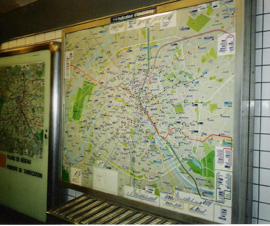
Also, some of the really large stations have these big electric maps such as the one you see at right. You simply press a button corresponding to your starting point and end point, and it lights up your trajectory on the map. These are comparatively rare, however, so don't count on them. Practice with the short lessons above.
(Note that you can't do all the possible connections on the little map I cut out above, because you can't see the names of the directions for many of the lines, since I could only reproduce a small portion of the total map here. Once you feel comfortable with the examples I gave, practice on a full-scale map.)
Advanced use.
Sometimes a direction can have more than one name. "Oh no!" you're saying. Relax. Look at pink line number 7. You'll note that at "Maison Blanche" it splits into "Villejuif-Louis Aragon" and "Mairie d'Ivry." That means that after "Maison Blanch" the train will go only in 1 of these 2 directions. You don't care, though, unless you're going to one of the 9 stops after Maison Blanche. In other words, if you were going to Tolbiac (right before the split) you can get on a train going to either one of these directions. If, however, you were going to, say, Porte d'Ivry, you'd have to wait for a train that was going in the direction of "Mairie d'Ivry." Don't panic. It's really pretty rare that you have to worry about a condition such as this. Also, you note that in the direction "Boulogne Pont de St-Cloud" there's this weird little loop. Look at the arrows: they show you which way around the loop the train goes.
Try to be calm. The metro is your friend. It smells like your Lionel electric trains from when you were a kid, it's very clean, it's very safe, and it's very cheap. Trains come with much, much greater frequency than the New York subway, and you're never more than something like 60 meters from a stop—and in most places it's much closer than that.
Buses aren't too complicated, and I'd show you but I can't find a bus map to scan right now. The only thing you need to know is that some buses don't run in the evening or on Sundays or holidays, but generally speaking it will say that at the bus shelter or on the map they have at each bus stop (again, it's very user friendly).